Latest Hurricanes , Tropical Cyclone, Strom updates
System 92L in Atlantic Getting Organized in a Tropical Way
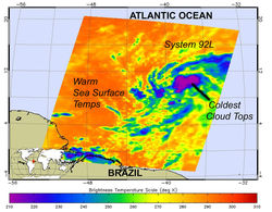
NASA's Aqua satellite flew over the low pressure area on June 14 at 04:29 UTC (12:29 a.m. EDT). The Atmospheric Infrared Sounder (AIRS) instrument detects heat (and cold), and provides a great snapshot of the temperatures associated with the developing low and the ocean waters that lay in its path.
The low pressure area getting better organized and AIRS infrared imagery revealed there are some high, cold, strong thunderstorms in some of the areas of the low. AIRS data showed that some of the cloud tops are as cold, or colder than -74 Fahrenheit (- 58 Celsius and 215 Kelvin). AIRS also provided a look at the sea surface temperatures in the direction that System 92L is moving, and noticed they are about 80 degrees Fahrenheit or warmer (300 Kelvin or 27 Celsius) , warm enough to support tropical cyclone development.
At 8 a.m. EDT on June 14, System 92L was located about 1425 miles east-southeast of the Windward Islands. Looking at a map of the Atlantic, the low also sits far north of the eastern-most tip of Brazil. The center is difficult to determine but appears on NASA satellite imagery to be between 4 and 8 degrees North latitude and between 32 and 40 degrees West longitude.
Rainfall Estimate for Cyclone Phet

Rainfall estimate map showed Cyclone Phet’s heaviest rainfall (600 or more millimeters/23.6 or more inches) occurred over open waters of the Arabian Sea (blue) Northeast Oman received as much as 450 millimeters (17.7 inches), while Pakistan received between 150-300 millimeters/ 5.9-11.8 inches. The colored line indicates storm track and intensity.
The Tropical Rainfall Measuring Mission satellite, known as TRMM is a “flying rain gauge” in space, and can provide rainfall estimates from its position in orbit around the Earth. Data accumulated from TRMM enabled visualizers to create a map of rainfall generated by Cyclone Phet as it marched through the Arabian Sea from May 31 to June 6. The heaviest rainfall occurred over open waters, but Phet dropped very heavy rainfall over parts of Oman and Pakistan.
TRMM satellite rainfall data estimated Cyclone Phet’s heaviest rainfall (600 or more millimeters/23.6 or more inches) occurred over open waters of the Arabian Sea. One area of northeast Oman received as much as 450 millimeters (17.7 inches), while Pakistan received between 150-300 millimeters/ 5.9-11.8 inches as Phet made landfall there this past weekend.
Tropical Cyclone Phet brought not just strong winds but also heavy rains to the Arabian Sea, the Arabian Peninsula, and the coast of Pakistan in late May and early June. Phet reached its greatest intensity off the coast of Oman on June 3. After making landfall in Oman, Phet dissipated somewhat, but remained organized enough to move back over the Arabian Sea toward Pakistan.